server mapysr logo

TOURIST MAP SERVER ATTRACTIONS OF SLOVAKIA.

- are you fond of tourism, Slovakia's attractions?
- interactive map offers pictures
- map objects are inserted with GPS position data
line
slovak version
podklad
+
-
all map
top
right top
left
right
left down
down
right down

Warning: file_exists() [function.file-exists]: open_basedir restriction in effect. File(../../obr/obrazky3/-1_-1.gif) is not within the allowed path(s): (/home/vv040500:/usr/share/pear) in /home/vv040500/www_root/functionEN/zakladna_mapa.php on line 111
mapa

Warning: file_exists() [function.file-exists]: open_basedir restriction in effect. File(../../obr/obrazky3/0_-1.gif) is not within the allowed path(s): (/home/vv040500:/usr/share/pear) in /home/vv040500/www_root/functionEN/zakladna_mapa.php on line 123
mapa

Warning: file_exists() [function.file-exists]: open_basedir restriction in effect. File(../../obr/obrazky3/1_-1.gif) is not within the allowed path(s): (/home/vv040500:/usr/share/pear) in /home/vv040500/www_root/functionEN/zakladna_mapa.php on line 135
mapa

Warning: file_exists() [function.file-exists]: open_basedir restriction in effect. File(../../obr/obrazky3/-1_0.gif) is not within the allowed path(s): (/home/vv040500:/usr/share/pear) in /home/vv040500/www_root/functionEN/zakladna_mapa.php on line 147
mapa
mapa
mapa

Warning: file_exists() [function.file-exists]: open_basedir restriction in effect. File(../../obr/obrazky3/-1_1.gif) is not within the allowed path(s): (/home/vv040500:/usr/share/pear) in /home/vv040500/www_root/functionEN/zakladna_mapa.php on line 183
mapa
mapa
mapa

Municipality - Nezbudská Lúčka
Marked track - Brusno Spa
Dolny Harmanec turning
Stare Hory, near the chapel
Yellow marked track - Martin
Kraliky U Ruskov - touristic marked tracks
Bystricke saddleback
Blue marked track - Janko Bojmir
Typical carst hole - blue marked track
Caldera centre - Polana
Educational footpath Batovce
Hill Dry Bela
Educational footpath Manin gap
Educational footpath Sulov rock
Tatra magistrala
Educational footpath crest Velka Fatra
Educational footpath in Pecenice
Educational footpath Rusovce - Rusovce Channel
Educational footpath Unatin H. Badin Cabrad
Mining footpath
Educational footpath Driencansky carst
Educational footpath Smolenice carst
Educational footpath Chasm of Hornad
Educational footpath Boky
Sad saddle
Rock view
Tomasovska Bela


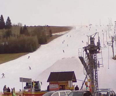
Ski Kosutka Ski Kosutka

Ski Kosutka

ciara
Brand of object - Down-hill tracks, accommodation in map
Position data GPS λ = φ =
Accuracy GPS is adjustment to 100 metre.

Attraction Ski Kosutka was in database embedded 15.02.2011 .
line


Down-hill track - Kokava Linia | Down-hill tracks - Kokava Linia | Front Polana | Ski areal near Cottage over Tajov | Ski Bachledova dolina | Ski center Jasenská dolina | Ski center Oscadnica Velka Raca Laliky | Ski center Valcianska dolina | Ski centre - Tale | Ski centre Donovaly | Ski centre Chopok South | Ski centre Jasná - Chopok north | Ski centre Krahule | Ski centre Kraliky | Ski centre Mýto pod Dumbierom | Ski centre Sachticky | Ski Centre Small Lucivna | Ski centrum Certovica | Ski centrum Kubinska hola | Ski Cierny Balog | Ski Drienica | Ski Fackovske saddleback | Ski Chopok south | Ski Kosutka | Ski Latky | Ski Latky II | Ski lift on Hrebienok | Ski Lysa | Ski Malachov | Ski Medvedie | Ski Milotín - Zuberec | Ski Nizna Uhliska | Ski Oravice | Ski Oscadnica Velka Raca Dedovka | Ski Plejsy | Ski Podbanske | Ski Polomka Bucnik | Ski Poruba | Ski Racibor - Oravsky Podzamok | Ski Rohace | Ski Ruzomberok | Ski Salamandra | Ski Selce Cachovo | Ski Skalka | Ski Stary Smokovec | Ski Strbske Pleso | Ski Tatranska Lomnica | Ski Telgart | Ski Turecka - Krizna | Ski Vernar Studnicky | Ski Vratna | Ski Vratna - Stary dvor | Ski Zavazna Poruba |

© 2008 www.mapysr.sk